(评论)
(comments)

原始链接: https://news.ycombinator.com/item?id=38139687

是的,根据产品描述,它出现在 eBay 上的“已售商品”列表中,表明拍卖成功结束,该单位以 12 美元售出。 然而,如前所述,由于地区或出价动态的差异,定价和货币换算有时可能会出现差异。 尽管如此,它还是让我们深入了解老式 GPS 设备的潜在价值和兴趣。

相关文章

原文
Hacker News new | past | comments | ask | show | jobs | submit login
A 6 channel GPS receiver from 1993 (mastodon.sdf.org)
230 points by edent 1 day ago | hide | past | favorite | 69 comments


The original GPS receivers in the late 80s and early 90s did not have maps. And they used LCD screens. The one I owned by Lowrance required 6 AA batteries. Not AAA. Not rechargeable. Optional power through a cigarette-auto cable, but that's not helpful when on foot. It burned through batteries like crazy.

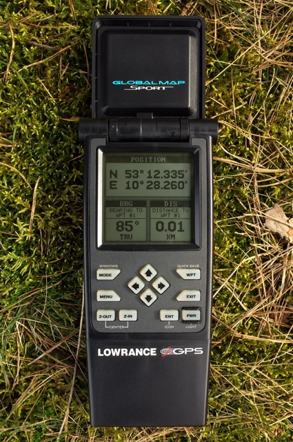
I owned this one: https://web.archive.org/web/20231104153749/http://retro-gps.... (Lowrance GlobalNav Sport) 160 x 160 pixel display. It weighed 2 pounds with batteries.

It provided latitude, longitude, and heading.

Thought I would use it hiking but it was just too big to be anything but a toy. You inserted a cartridge, specific to your geographic area, if you wanted it to display names of towns/cities (data on the cartridges):

https://www.ebay.com/itm/314936082464

It did have "waypoints" (lat/long bookmarks, essentially) that allowed you to plot a line as you traveled. It could tell you how far you were to different waypoints you'd previously entered. IIRC, it had a serial connection for waypoint download to a PC. People tried sharing waypoint series -- "routes" -- but it just never really had much success as I recall. It was just too cumbersome.


The first "portable" GPS receiver I ever saw was during a tour of a relative's military base in the mid to late 1980s.

It was mounted in a travel case where the lid removed exposed the control panel. I want to say it was about the size of a shoe box. Similar in length and height to one of those hinged metal ammunition cans, but wider if I remember correctly. It seemed hefty enough to have a lead-acid battery inside, but they did not give details.

You set it on the ground and waited minutes for a fix. Then it just displayed numeric grid coordinates of your location with segmented digit display cells somewhat like a 1970s calculator.


That Lowrance is a monster. Pretty cool though.

My first GPS receiver was an old Magellan. I can't recall the model, but mid 90s, very basic features. Eventually after turning it on it would get a fix, and give you coordinates / speed / bearing. No names of towns or anything like that though it did have support for some number of waypoints.

I typically used it for multi week hikes through the rockies where I was navigating primarily with topo maps & compass, and about once a day I'd turn on the GPSr to validate my location. It was too much of a pig on batteries to use it any more often, but, it was a reasonable size for hiking.

Totally different world vs the Garmin GPSMap 66i I currently use, but, I'd probably trust the old Magellan more than I do 66i on week/longer excursions.


    > about once a day I'd turn on the GPS to
    > validate my location.
This point can't be stressed enough, these early GPS models (and even one I owned in the early 2000s) often served a fundamentally different use-case than what people think of as "GPS" today, which has come to mean something with integrated maps and navigation.

The idea with many of these early devices was exactly what you're describing, experienced hikers who'd mainly use a map & compass to navigate might buy these. It was enough to have one GPS for the entire group, and on a typical trip with good visibility and orientation the GPS might never come out of the backpack.

But knowing where you are if you manage to completely lose orientation (e.g. with an onset of fog) is invaluable. The original use case for GPS devices for hikers was that sort of fallback safety.


Which model was yours? This page appears to show every model of handheld GPS ever made, and Lowrance has 4 entries.

Thanks for sharing this, I never had the chance to see one of these units. It's so weird now to imagine GPS with no map!

P.s. What does a six-channel GPS receiver even mean? Is more channels more better?


>What does a six-channel GPS receiver even mean? Is more channels more better?

The operating principle of GPS is more complex than I can usefully summarise in a comment, but essentially the satellites are continuously broadcasting an extremely accurate time signal that the receiver uses to calculate the time-of-flight to each satellite. GPS receivers need signals from a minimum of four satellites to provide a location fix.

There are usually more than four satellites visible, so additional channels allow for more than the minimum number of signals to be received. this can provide improved accuracy, faster time-to-first-fix and better resilience to interference. If you're receiving five or six signals, you don't lose your positioning fix when one of the satellites moves below the horizon or is obstructed by terrain. Reflected signals can cause error, because the time-of-flight of the signal will be greater than the actual distance to the satellite; extra channels allow these errors to be compensated for.

For a long time, GPS receivers typically had no more than 12 channels, which was the maximum number that would actually be useful given the limited number of satellites in the original GPS constellation. Since then, many other navigation satellite constellations have launched, so between 40 and 60 navigation satellites are typically visible at any moment. Receivers have commensurately improved, with even basic receivers often having upwards of 48 channels.


How does encryption work on GPS signals? Since it seems the military have access to better accuracy, it’s not just a wavelength that is broadcasted.


Prior to 2000, the civilian signal (C/A code) was deliberately degraded by the addition of small random variations in the time signal, but this is no longer the case. A separate military signal (P-code) still exists, which is encrypted in order to prevent spoofing; to my knowledge, the encryption scheme used for the military signal is still classified.


Here's a better picture of what I owned. It had a huge hard-plastic case:

https://www.ebay.com/itm/314936082464

The antenna flipped up and doubled as a screen protector:

http://retro-gps.info/photos/files/page2-1023-full.jpg

https://i.ebayimg.com/images/g/zxUAAOSwDspimA3F/s-l1600.jpg

Sorry, I don't remember what 6-channel means. I would guess it could receive data from up to 6 satellites? Don't know.

IIRC, this cost about $700 but cartridges were extra. Very expensive for the time. It worked without the cartridges, but I think it only displayed lat/long then, or in any case much more limited info. The carts added more info like town/city/state.

Unfortunately, I could not find any YouTube videos of early GPS receivers.


Thanks @TDT for your prompt and rapid reply, always nice to connect with such a generous person who indulges me :D.

What a spiffy looking unit, it looks like belongs mounted in the dash of a 198x Mercedes, Porsche, Corvette, Bronco, or similar alongside one of those old school built-in car phones.

Archive links of the eBay resources:

1a. https://web.archive.org/web/20231104152903/https://www.ebay....

1b. https://archive.ph/QxwrN

2a. https://web.archive.org/web/20231104153359/https://i.ebayimg...

2b. https://archive.ph/crpGm

(Adding because of how many broken eBay links I've encountered on forums over the years.. it's always frustrating, haha.)


You're welcome! This is the best photo in my opinion -- shows the antenna up (not covering screen), unit is powered on, and the unit itself is in excellent condition:

https://web.archive.org/web/20231104153749/http://retro-gps....


https://digitalcommons.usu.edu/cgi/viewcontent.cgi?article=2...

> The receiver has six channels that continuously track four primary GPS satellites and sequentially acquire and track all other visible and healthy satellites on the fifth and sixth channels.


Wondering why « No rechargeable » ? I recall rechargeable AAs in late 90, didn’t they exist in early 80 ?


Even in the early 90s my good rechargeable batteries (AA) only put out 1.2v when freshly charged and dropped lower than that as they ran. They also ran far shorter than duracell or similar expensive batteries.

So one the voltage may have been too low and two the usable loge might have been too short for these power hungry devices


Nickel cadmium AA batteries (what was available in the 90s) were not great. They self-drained to flat after a month, and had "charge cycle memory," so if you discharged them a couple times to, say, 60%, that became the cell capacity. Even fully charged, they only put out 1.2v.

Nickel metal hydride, and specifically Eneloops, were a game changer, as their self-discharge was only 10%/month, and had virtually no charge cycle memory.


Not OP, but i remember having a camera that use AAs and would not support rechargeable. While it powered up, it would not take photos and instead shutdown. I think they used to be able to deliver less power, also when i put them in the gameboy the little led was a tad dimmer that non rechargeable one even when fully charged


I had a radio that could handle rechargeable vs non - it included a dummy AA battery that you used when using non-rechargeable batteries, so you'd use (IIRC) 7 rechargeables + 1 dummy or 8 rechargeables.


Garmin handheld unit in the early 2000’s still had an LCD screen. I still have and use mine as a backup.


I have the eMap. Still works. In 2002 I tethered my laptop to my phone and connected the eMap to the laptop. I had custom Java software that would read my position from the serial connection, and then post it to a custom PHP page, and there was a different page where you could view my position on a Yahoo Map.


GPS seems fairly pedestrian now but my dad had one of the early Garmin models in the 90s and it was a kind of magic back then. Even outside of the actual location info, just seeing this thing in your hand listening to satellites up in space felt incredibly powerful. Later on you could get units compatible with Windows CE and mobile devices and it was easy to see why it would be a killer app on smartphones. It’s sad that the complexity and cleverness is all hidden now.


Also kids these days don’t know the pain of GPS taking 3-10 minutes to get a position fix without almanac data.


Yeah, navigating a big city meant finding a crossroads where you might be able to see a bit of sky. I used to wear a shoulder bag and attach the antenna to the strap to stay locked on.


Or the days before GPS where taking a road trip inevitably resulted in a big argument with your partner about directions


Back then even light tree cover would sometimes trash the signal enough to lose position.

While modern GPS can get a position fix pretty quick, a cold start on standalone units can still take a while before it discovers enough satellites.

The crazy thing to me is now days my little tiny watch can do Wifi, Several Bluetooth protocols, 5G, NFC, Wireless charging and probably some other stuff I'm forgetting about. Oh and it supports a variety of global navigation satellite systems. Don't forget the high-res OLED display too. And the fact it is fully watertight.

All that while having a fairly impressive battery life.


Take a look at the https://phyphox.org/ app for lower level access to the sensors on Android and iPhones. There is a GPS section that gives you coordinates but unfortunately doesn’t tell you about each satellite. The precision of other phone sensors seems even more amazing.


You could also try https://github.com/barbeau/gpstest if you are looking for something more GPS focused.


That looks pretty cool. Do you know if there is anything similar for iOS, or do Apple prevent apps from accessing those data?


There sure was when I still used iOS. But I don't remember the name.


I mean, both GPS and WiFi was super exciting stuff in the early 2000s. There was a GPS magazine for GPS terminal enthusiasts (!). It's still sort of around: https://www.gpsworld.com/.


It's a bit on the side, but I remember my father telling me that the PCB's he sold to the Eastern Bloc were often adorned with microscopic greetings in Cyrillic, though the Russian spelling was often pretty bad.

Just like now, the Soviet Union was under heavy sanctions, and they weren't allowed to receive the latest computer tech. The various companies had ways around this, though, and the saying was that they'd purposefully design their boards so that Russian engineers could "tamper" with them in order to achieve higher than allowed clock speeds.

Anyway this cute board just made me think of that, so thought I'd share it.


Betrayers of The Free World reap the benefits of living in The Free World the most, and advance ahead on the social ladder towards decision making positions, perpetuating these bad decisions.

And people who did the right decision, have to pay twice. One is the opportunity price, and another is the externality price.


If sharing useful tech is betrayal, I wish there would be more traitors. On both sides.


Tell me you're too young to remember the cold war without telling me ;-)


I am 41, so, old enough to remember the end of the cold war as a child. I was almost exactly 10 at the fall of the USSR.

But, maybe most importantly, I am not from the US nor Russia, I am French. And while we were on clearly the western side, we had a somewhat more nuanced view of the conflict, I mean, we even had (and still have) a communist party.


Another great explanatory page I have seen is:

https://ciechanow.ski/gps/

Comes with a lot of animations and interactive elements. Admittedly, I haven't gone through all of it yet since it so detailed, but it is marvelous.

Earlier discussion:

https://news.ycombinator.com/item?id=36180316


The interesting thing about GPS back then was that the location data you got back were randomly slightly incorrect every time you got a reading. I’m pretty sure this was so it wasn’t useful for military purposes.

I think it was called differential post correction but if you had a base station with a known location you could snap your incorrect points to the difference generated at that correction level and get the true location after the fact.

Source: GIS major in late 90s when this stuff was a lot more magical


That’s right. It was selective availability and you used differential post correction to clean the data up and get accurate locations for the data you were capturing. Thanks for the correction!


Adorable! As a former EE we often put little jokes and Easter eggs in prototype PCB designs. Sometimes they made it to production!


So cool to see how the technology has evolved over the years, now we can achieve accuracies down to one centimeter with GPS. Check out what Emlid has been building in this space. http://emlid.com


Centimeter precision still requires a base station. Gotta leave a GPS receiver stationary for days so it can average out the errors and compute its own position precisely. With that accurate receiver it's possible to correct the measurements of other receivers nearby up to some maximum range.

This requires raw GNSS measurement data support which is not available in most consumer units and is an incredibly proprietary mess in the professional surveying equipment space. It was actually Google who improved the status quo by mandating pseudorange support in Android.


Garmin had the 100 series in 1990

Neat history of GPS units

http://retro-gps.info/page33/index.html

But what's really interesting is the first GPS watch, the Forerunner 101 in 2003

https://www.garmin.com/en-US/p/231


That's cute!


All the real OGs remember having to haul the PLGR around Ft. Bragg.

https://en.wikipedia.org/wiki/Precision_Lightweight_GPS_Rece...


> Why is it shaped like an ambulance? Good question.

Was hoping there was an actual answer for that question. Or am I missing something? Otherwise reads like "good question, who fucking knows!? certainly not me the person making the assertion!"


Am I missing some sarcasm, or do you honestly think that the board in question doesn't look like an ambulance?


No sarcasm. Yes, it looks like an ambulance (seemingly deliberately). The tweet/fart/whatevertheyrecalled just has strange choice of phrasing implying they will follow up on this, then they don't. _Why_ is it an ambulance? Well who cares, I guess - but the author of the poof/squirt/whatevertheyrecalled is the one who draws attention to it in the first place.


It's a several decade old piece of hardware that was likely produced in extremely limited quantity, so finding the answer to that is probably not going to be easy. Presumably it was produced as a promotional item made to promote their GPS receivers for some kind of safety application that the ambulance shape is a reference to, but good luck confirming that in 2023.


Like I said, I don't really care. Those are all reasonable assumptions I guess. Just commenting on the toot author's phrasing.


Whoever designed the board may have just done it as a joke, but I think giving the coastguard etc. an idea of your general location when in distress would have been a good civilian use of GPS in 1993


But why is it shaoed so?


Why would someone in 1993 have had the foresight to think that they might need to know their location to within a hundred meters or so?


Hos


3760451


It sold for just $12 yesterday. (Some more shots here, too.)

https://www.ebay.com/itm/274506300217


I don't think it sold. The listing ended. Also add $6.50 shipping. Still worth it.


But it literally says: "Sold for: US $12.00"?


Guidelines | FAQ | Lists | API | Security | Legal | Apply to YC | Contact


Search:
联系我们 contact @ memedata.com